Day 115: 09 August, 20.6 miles today, 1813.6 miles total, Gallatin NF, MT
Big Sky Alternate, day 01
The end always happens suddenly, no matter how long you’ve had to prepare for it. Even in the morning it was still hard to believe that Sean Meadow wouldn’t be hiking out with us after breakfast. She’d been such an integral, seemingly permanent part of the CDT for all of us; but when the time came for the four of us to get walking, we said our goodbyes and started down the road without her. Just like that, we were hiking on without her.
Our chosen route out of West Yellowstone began in a way that felt almost intentionally suited to the sort of creeping melancholy you’d expect when you resume hiking without the partner with whom you’d been sharing the trail for 16 weeks. We had to walk 7 miles down a paved highway with wide, forgiving shoulders before turning onto a paved highway for 6 miles with narrow, cramped shoulders before turning onto a dirt road with no shoulders for 2.5 miles before finally coming to a trail. Most of the day was exposed, walking in straight lines without anything much to look at, and nothing but your thoughts to distract you from the monotony of the traffic.
A challenge presented by the Big Sky Alt which had heretofore not had to contend with was the fact that we now had to make educated guesses as to the location and quality of water sources. We’d been spoiled by having reliable information up to that point, but now we were kind of on our own, never quite sure when we passed a stream or a small dribble whether the next one marked on the map would be flowing. Which is how we came to be huddled around a “surprise trickle” that hadn’t been noted on our maps when a woman on horseback came trotting up.
I know that I’ve talked a fair amount of shit about horse riders before, but this woman, beyond simply being friendly, seemed genuinely concerned about the quality of the trail. When she started complaining about dirt bike riders and the way their wet-fart machines destroy any path they use, she won me over completely. We spoke for a few minutes about the CDT and where we were all from, and then she started making her way past us. Once she was clear, she turned and said, “you seen any grizzlies?” We hadn’t. “You will. Lot of bears ‘tween here and Canada. You got bear spray?” We did. “Good. You got guns?” We did not. She rode off, shaking her head in disgust. It was only then that I noticed the holstered revolver on her hip. It was massive.
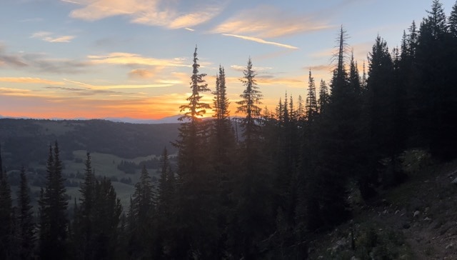
We only hiked on a couple miles beyond that, making camp on a low pass with a sweeping view of the sunset. We were one day into our last state on the trail. Now it was time to see what Montana had to offer.

Day 116: 10 August, 23.5 miles today, 1837.1 miles total, Gallatin NF, MT
Big Sky Alternate, day 02
The previous day’s hiking had set expectations fairly high. The Red Canyon Trail, which we’d taken all the way from the dirt forest service road to camp, was in phenomenal shape by CDT standards (though the horse woman had expressed some contempt for the trail’s current state). The Skyline Trail, by comparison, was crap. At least, many of the first few miles we walked after switching trails first thing in the morning were not trail at all, but a stunning walk through lumpy meadows from one trail marker to another. The going was surprisingly slow, and by the time we stopped for lunch on a rocky, rounded peak, I had multiple hundreds of burrs to pick out of my socks.
The views were good, at least. We were back in mountains again, so there was something to look up at and admire while trudging through knee-high brush or up a long slope in direct sunlight. By lunch, a thick white haze had started rolling in from the SW. Clearly, there was a fire burning somewhere, as the smoke was starting to settle in the valleys below. So much for the views.
We started down off the ridge, during which I learned three things: 1) I was almost out of water, 2) the next water source was 5 miles away, and 3) the map set we were using was in reality only sort of vaguely accurate. I hadn’t yet internalized the vigilance with which I’d need to monitor the evolving water situation—I should have gotten a couple of liters while I was still in the meadows, but I’d forgotten to check. That lesson was hammered home over the next couple of hours as I followed the only trail on this side of mountain, watching with growing horror as it continued to deviate from the route outlined on the map, running parallel to a stream in the valley below without ever getting nearer to it. For a mile or more, I walked through a field crawling with hundreds and hundreds of damp, slimy, barf-colored crickets so fat that as each tried desperately to hop away at my approach, it invariably wound up helpless on its back. All told, it was closer to 8 miles before I finally got to the creek.
Once I’d filled up on cool, clear creek water, I ran into the group taking a break 1/4 down the trail. We now had to navigate around a narrow belt of private land whose owner had been complaining about hikers walking through his property. The problem was that the trail we were on lead straight into his land, and the fastest way to get out was to make a sharp turn leading deeper in. After passing through a series of gates, we were able to follow the fence line from the outside until we rejoined the trail that would take us down to the road.
It was not a great road. A two lane highway in the middle of nowhere, cars flew by as we walked along a shoulder that could barely have been said even to exist. A mile or so from where we hoped to camp, we stopped for a dinner break at the entrance to a Forest Service road. The evening meal had been largely subdued the last couple of days; occasionally one of us would speak up, but the group would almost immediately fall silent once again. As we sat in the gravel boiling water, Elf spoke up, “If you’d have told me that when I was 40 I’d be sitting on the shoulder of a highway cooking ramen, I wouldn’t have believed you.”
“Ehhhh,” replied Unknown, “I think we all saw it coming.” And so we are.
Day 117: 11 August, 13.0 miles today, 1850.1 miles total, Big Sky, MT
Big Sky Alternate, day 03
It was raining when we woke up in our campsite, an overgrown clearcut tucked behind a row of trees on the side of US Hwy 191–but it was technically Forest Service land, so we were basically in the wilderness despite the sound of the semis barreling down the road all night long. It had been my second and last night alone in the big tent I had shared with Sean Meadow, which by myself was large enough to be disorienting in the early morning. In Big Sky, I would pick up my old, smaller tent, as well as a care package from my friend K that would cover my resupply needs all the way to Whitehall. But first I had to get there.
We had a sizable roadwalk before us, with only a scant 18” shoulder for most of it. Every 30 seconds, we would have to veer off into the ditch to allow room for the speeding cars, trucks, and RVs to blow by us. The rain, of course, made everything worse. We were anxious to get to town, but we had to wait to get started, as the dim light of the gray, wet non-sunrise made walking on the highway too dangerous. Even when it got a bit lighter, we walked with our headlamps on in the hope they would make us more visible. And so the dance in the damp went, until the skies finally cleared and a bike path miraculously appeared next to the road a few miles from town.
Big Sky is not so much a town as it is a massive, sprawling, very posh ski resort—which is a bit baffling, as there was no evidence of the sort summer goings on you see in most such places in the warmer months. There was no evidence of mountain biking, hiking trails, or any activity save for the construction work that seemed to be going on everywhere. Even so, the pricey boutiques in the downtown area were open and even bustling, which did us little good from the mountain-side condo Elf had found for us on Air BnB. The only restaurants open in our neighborhood were far too expensive for four simple hikers, so we bought dinner from the resort convenience store. Surrounded by multimillion dollar houses and other opulent displays of wealth, we dined on frozen pizza and boxed macaroni and cheese. In no other town had we felt so our place, but as long as there was cheap comfort food to be had, we would make it home.

Day 118: 12 August, 12.7 miles today, 1862.8 miles total, Lee Metcalf Wilderness, MT
Big Sky Alternate, day 04
The worry that we had each secretly harbored when planning for this route was that we would be sacrificing the quality of the trail for simple expediency. This fear had been bolstered by the two and a half days into Big Sky—which had included a dozen very scenic, if hard to navigate, miles, but which had mostly consisted of a mind/soul-numbing walk along a busy highway. The section of the redline that we were skipping was reported not to be terribly scenic, but it was also supposedly not without its charm in the way that, say, US 191 had been.
The first day out of Big Sky did not start out very promisingly. The first few miles were, in fact, an exhausting uphill slog on a busy highway under a burning sun. Things started getting better when we turned off onto a dirt forest service road, and better still when we got to a trailhead and finally walked back into the woods. The trail was wide and well maintained, following a picturesque mountain stream, which babbled happily as we slowly climbed up the valley. Eventually, the trees started to thin and we got our first clear view of the Spanish Peaks. We hadn’t seen country like this since we’d left the winds: high granite ridges carved in sharp, pointed crenellations. It was a breathtaking sight.
As the trail started pushing upward, I caught sight of Elf up ahead waving his arms in the air. I was confused as first, as I’d just check my location and was confident we were on the right path. When I caught up to him, though, he told me that he’d just seen two black bears nearby, and had decided it was better to wait for me that to push on alone through the area noted on our maps as Bear Basin. I was disappointed not to see any bears of any kind, myself, but it was nice to admire the surrounding mountains aloud as we shared our relief that the alternate we had chosen to take was turning out to be worthwhile on its own merit.
We made camp by a small lake after descending what would most like turn out to be our last pass over 9,000’. The mountains were getting lower the further north we got, but these were no less magnificent for their technically shorter stature. This would be my first night on the CDT in the smaller tent I used while hiking the AT and the PCT without a significant other, and the first thing I noticed when I crawled inside was a hole in the mosquito netting that I had apparently left unrepaired. I patched it up as best I could and then lay in what now felt like a tiny home compared to the backcountry mansion I’d shared with Sean Meadow, listening to the approaching thunder of a storm the forecast had all but guaranteed would never come this close.

Day 119: 13 August, 19.9 miles today, 1882.7 miles total, Gallatin NF, MT
Big Sky Alternate, day 05
It was a day of constant ups and downs, which made the going awkward and slow. The views of the Spanish Peaks were good, while they lasted; but by late morning the trail had disappeared into the treeline, which kept the scenery fairly limited the rest of the day.
After lunch a thunderstorm started building just to the east, which only kept building over the next hour or two. In theory, the weather was blowing away from me, but the near-constant thunder seemed to be getting ever closer as the storm mushroomed outward. As the afternoon light dimmed under the darkening clouds, I lost the trail. Once again, my map was doing a poor job representing the location of the path I was trying to walk as it existed on earth. I was starting to seriously worry about being caught in what was shaping up to be a pretty powerful storm, when all signs of it abruptly stopped. The thunder vanished, and the sun came out to shine on the forested mountainside I was bushwhacking across. I was eventually successfully able to predict where the real trail would re-emerge, and shortly afterwards met up with the rest of the group sitting by a small creek.
The last couple miles of the day were an intentional bushwhack, which I won’t pretend was easy for me, but which admittedly could have been a great deal worse. Mostly, it was exhausting, leaving me with barely enough energy to pitch my tent and eat dinner before slinking off to the safety of my shelter just before the wind picked up to the sort of tent-shaking abomination that keeps you up all night. It had been a long, tiring day, but it wasn’t done with me yet, apparently.

Day 120: 14 August, 27.2 miles today, 1909.9 miles total, Beaverhead-Deerlodge [sic] NF, MT
Big Sky Alternate, day 06
The term “hiker hunger” refers to something more than the gnawing pit in the stomach you get at the end of a day spent burning a ridiculous amount of energy: it becomes a permanent part of you, a hollow that you can never quite fill, a fire inside you through which all food will pass without touching. You begin every meal knowing that you will still be hungry when it is over. It makes rationing difficult, but more important than ever, as you don’t want to find yourself without anything to eat for lunch one day because you had a double helping the day before.
I had had a healthy appetite the entire length of the trail, but it wasn’t until the stretch after Big Sky that I found myself always uncomfortably hungry—and if anything, thanks to the care package sent to me by my friend K, I was carrying more food than I typically did. But no amount I could keep on my back would be able to quell the riotous, seething emptiness in my tummy.
We hiked out of one set of pretty mountains, across a wide, flat valley with a large lake at its center full of agricultural runoff, and up into another set of pretty mountains. The views were great, the walk on the dirt road was horrendously hot and sweaty and bright and unshaded, and we made good progress toward our next town—but all I could think about was food and drink. Every time a car passed on the road, I telepathically demanded “GIVE ME A COLD SODA,” but apparently I needed more practice bending strangers to my will through the power of my mind.
This was demonstrated most clearly by the drivers who pulled over to ply me with questions about the CDT and the Big Sky Alt, whose single-minded conversation I was unable to steer toward cold beverages. There was a couple toward the end of the day I felt sure was on the verge of offering me some kind of refreshment, but after the husband finished talking to me about my route, he drove off while his wife was still attempting to talk to me. A few minutes later, I found Elf getting bombarded with questions by the wife at the campsite she insisted they wouldn’t be staying at, her husband taking things out of the truck and carting them into the woods. Elf masterfully brought the conversation around to cold drinks, but to no avail.
The day’s greatest tragedy, however, was that the bar in the tiny blip of a town we breezed through in the morning was reported to serve “the best mac and cheese on the CDT,” but it wouldn’t open until the late afternoon…long after we’d passed by.

Day 121: 15 August, 24.0 miles today, 1933.9 miles total, BLM land, MT
Big Sky Alternate, day 07
I slept more soundly than I had in days. There is perhaps no greater feeling on this poor earth than sleeping next to a gushing, rushing creek on a cool, clear, still night. The only drawback is that you don’t ever want the sensation to end, which makes it incredibly difficult to rouse yourself in the thin hours of the morning to pack up your tent and start hiking.
It was important to get an early start, though. I’d been mistaken that we’d already made our last climb above 9,000’—we still had one more left, and we wanted to get it done before the day heated up. The cool morning air really helped, and it felt like we were sitting at the pass before we even knew what had happened, laughing and snacking and marveling at the complete solitude we felt in these mountains. The ruins of an old gold mine—complete with a 40’ shipping container that had to have been helicoptered onto the side of the mountain—lay a 1/4 mile down a gravel path from the pass. Unknown and Elf went over to take a closer a look (and to try to get into the shipping container), while PA and I started the harrowingly steep and rocky descent. Several times we stopped to examine one piece of mining detritus or another: an ancient bulldozer, or the ruins of an old well. We passed hand-built cabins long fallen to pieces, and even a small shower with a pane of glass for a skylight.
After lunch, we walked a dirt road though a valley, passing through Mammoth, one of the smallest towns I’ve ever seen. Two roads, maybe five dozen cabins and cottages, no stores, no services, nothing but seasonal residences surrounded by hulking mountains and a small construction crew working to resurface the main dirt road.
The rest of the afternoon was a blur of heat and steep trail and foot-twisting rocks. We camped on the last bit of public land before starting tomorrow’s road walk into the town of Whitehall. We ate late, watching the sun sink behind the mountains across yet another wide, flat valley. It would a hot walk without any signs of shade or shelter—but that would be tomorrow’s problem. Tonight we’d just watch the dusk roll in and try to get some sleep.

Day 122: 16 August, 17.9 miles today, 1951.8 miles total, Whitehall, MT
Big Sky Alternate, day 08
I was a good hour into the day’s roadwalk into town when I happened to look down at my can of bear spray and saw that the safety clip was missing. It was, first of all, baffling how anything that could have dislodged the clip would not also have discharged the spray—but it was also a small miracle that it hadn’t accidentally been triggered at any point during the window when I wasn’t aware I was a carrying a weapon with no safety. That stuff is nasty, formulated to stop an angry grizzly. I shuddered to think what might have happened while hoisting my pack over the barbed wire fence we crossed that morning* or even just sitting down to breakfast.
The walk was fine, if boring; though it did become uncomfortably hot during the last hour or two as late afternoon crawled into midday. By the time I joined the others at a small, local sandwich and ice cream shop, I’d worked out a system whereby I’d prevent accidentally shooting off my bear spray by carefully removing it and setting it somewhere safe before unshouldering my pack. It was a stopgap solution at best. After we set up “camp” in the garage adjoining the Whitehall town hall,** Elf jury-rigged a safety pin from a piece of shielded wire he found. It was a good idea, but too thin to trust, and it ultimately failed the “accidental discharge test” I put in through behind the building. I could order a replacement clip online, but that would mean I’d have to hike with a trigger-ready can of pain potentially for weeks. I could buy a new canister altogether, but as they could run $50 or more, I wasn’t keen on laying out that much just because I’d lost a $2 part.
Which is when it occurred to me that Elf had been on the right track; he just hadn’t had the right piece to make it work. But there was a hardware store in town, and after browsing the fastener aisle for a couple of minutes, I had the answer in my hand: a simple hitch pin, which would prevent the trigger from accidentally being pressed and which I could easily pull like the pin in a grenade if I ever actually had to use it. It was perfect, a 75¢ solution to a $50 problem. Now if only there were a similarity easy answer to the brutally hot weather in the forecast, everything would be perfect—or close enough, anyway.

*the others went over the top, but after seeing how close both PA and Unknown came to testicular disaster, I opted to shimmy underneath—all while what I assumed was a juvenile bull kept half-charging toward us and then leaping comically away.
**It looked as if the place had been built to serve as a small-town fire department (and reminded me of no place so much as the FD in DeFuniak Springs, where Sean Meadow and I had spend a miserable night in the Florida section of our cross-country bike trip), but had been converted instead to administrative purposes. What would have been the truck bay—where we slept—was mostly used for file storage, as well keeping a few odds and ends. It wasn’t necessarily the most comfortable place we’d ever stayed, but it was the only option in town, and it was a free roof over our heads, complete with bathroom, shower, and laundry. It was a surprisingly comfortable space, generously offered with no expectation of payment, and we were extremely grateful to have it.

Day 123: 17 August, 24.2 miles today, 1976.0 miles total, Beaverhead-Deerlodge [sic] NF, MT
Big Sky Alternate, day 09
The Whitehall town hall garage, despite being a large, open space, was extremely stuffy. That, combined with the excessively bright street lights shining in through the windows, made sleep somewhat difficult, and as a result we were all fairly reserved, groggy, and quiet for most of the day. For once it wasn’t just me.
Breakfast was jovial enough, though that was probably due to the mixed influence of good food, a cheerful, bubbly server, and several cups of coffee—otherwise most of the day was spent in silence, even when we were all gathered around for lunch and dinner. It wasn’t a terrible day, though it was terribly hot for much of the afternoon as we climbed uphill sharply along an exposed dirt road. But we were tired. Whitehall had been very good to us, despite the uneasy night of sleep. Now that we back to walking up long, dry mountains without much to look at we could tell that we were getting close to the redline. In fact, we camped less than a mile from the CDT proper. The last few dozen miles had been hot, dry, and boring, but at least we were almost home.

Day 124: 18 August, 8.5 miles today, 1984.5 miles total, Butte, MT
Big Sky Alternate, day 10 (sort of)
“It’s not a big deal,” Unknown said as we all packed up our tents by the red glow of our headlamps, “but I thought we were sleeping in this morning.” Oops. I guess I missed that discussion, as I had started the process of getting up shortly after 0500hrs, and unfortunately no alarm is more effective for a hiker than the piercing hiss of a deflating sleeping pad.
It had also become pointless to get up that early. I was ready to hike by 0545, which had been “first light” only two weeks before; but now, reluctant to charge into grizzly country with only the narrow beam of my headlamp to see by, I just sat in the dark, listening to the owl calls echoing through the woods as I waiting for the sky to lighten enough to start walking. It was 0610 before we left camp—clearly I afford a few more minutes of sleep in the morning.
A few minutes later we were back on the CDT proper, walking the redline for the first time since we’d left it in Yellowstone to take the boardwalk through the Norris Geyser Basin—where the official main trail followed a paved pathway into the woods from which, frankly, you couldn’t see shit. This was, strictly speaking, the end of the Big Sky Alternate. We’d be back to following the more clearly-defined footpath, which had substantial benefits like reliable water reports and a trail that didn’t regularly veer an unexpected half mile from the line on the map. But it was still in a way bittersweet to leave behind the patchwork of information and guesswork that had made up the alternate route. The only thing we’d ever known for sure at any point along the way was that it was possible. The how had been up to us.
Another, much more surprising benefit to returning to the CDT was the first bit of trail magic we’d seen since we were a few hundred miles into New Mexico. I hadn’t expected to catch the rest of the group until the highway into town, at least, but I found them clustered around what was unmistakably a cooler, in the woods, with the letters “CDT” written on it in marker. It was full of sodas and water—perfect for a hot day, and not half bad for a warm morning. It was a truly unexpected treat, and with bellies full of bubbles and sugar we covered the remaining distance to the road in no time. An hour from the moment I had sat on a log relishing the taste of an orange soda, we were walking the streets of Butte, three of us with new pairs of shoes on our feet fresh from the post office. We were ready to take on the rest of the CDT, but not before we’d take on a late breakfast and a day and a half luxuriating in bed.

Day 125: 19 August, 0.0 miles today, 1984.5 miles total, Butte, MT
The first thing you notice on the way into Butte is the giant, gaping hole in the ground at its NW corner. It looks almost necrotic, like an infected wound in the city’s shoulder. It is, in fact, one of the largest Superfund sites in the country: an abandoned copper strip-mine, so polluted that the last time a flock of snow geese landed on the water that filled the pit over years of disuse, between 3,000 and 4,000 of them died. Since then, the agency managing the site has installed safeguards to deter birds from landing on the acid lake, since no one seems to have any idea how to actually clean it up.
You can see the massive orange-hued scar carved into the lush, green hills from pretty much anywhere in Butte, which is otherwise a charming place with a large and well-preserved historic district full of old brick buildings on the pit side of town. In that way, the north end simultaneously shows off the best and the worst sides of the last century, as the south side demonstrates the convenience and depressing utilitarian blandness of modern-day suburbia. This whole strange milieu is surrounded by the ridiculously picturesque Montana Rockies.
As with most zeros, the day was a flurry of activity, though for the most part I didn’t have to leave the hotel room. I did make an expedition down to the local Dairy Queen, where I sat alone eating fried cheese and candy-laden soft serve, reading articles on the internet that reinforced my mixed feelings about the album Kendrick Lamar had dropped back in May. I was gathering my trash to throw it out when a noticed a man trying to get my attention. “Are you a thru hiker?” he asked. I told him I was—we really do stand out when you have an inkling what to look for—and he introduced himself, telling me he had hiked a few years back. The conversation was clunky and halting; I’d been too much in my own head to suddenly carry a conversation. It was a shame, because I would like to reward my fellow socially awkward introverts for making efforts like this, but I was floundering just trying to fill the silence. Most thru-hikers bypass Butte on the Anaconda Cuttoff, so seeing one in town was a rare treat I was souring with my own ineptitude at making small talk.
Which was, of course, my own interpretation of the encounter after it had ended and I’d made the walk back to the motel nestled beneath the ruins of the abandoned copper mine. I could continue to fixate on it, but the mesh panel on my pack had several holes I needed to repair before starting our last 420 miles north. Besides, on TV Harry Potter was about to battle a goblet of fire, and he would need me to root for him as I struggled to work a needle and thread in the most rudimentary fashion imaginable. I wouldn’t have the focus to spare on anything else.
