Day 16: 14 April, 15.6 miles today, 210.4 miles total, Fontana Lake North Shore, Great Smoky Mountain National Park
Number of people seen on trail: 0
At 0900hrs, the agreed upon time, I flicked off whatever inane nonsense I’d had on the TV, picked up my fully loaded pack, and walked outside my cozy little hotel room to meet the proprietor. The owner of the Hike Inn was a kind older woman who’d run the place with her husband for years before cancer took him—at which point, she just carried on running the place by herself. She catered to the AT and BMT hikers who were willing a pay a little more than your average bare-bones hostel for such luxuries as comfort and privacy, but who weren’t willing to pay $200/night to stay in some fancy-ass lodge. For a modest fee, she’d pick you from the trail, give you a private room, do your laundry for you, drive you into town for resupply and dinner, and return you to the trail the next morning. If she was a touch eccentric when I met her, well, it went with the job—but I didn’t once see her over the day and half I spent at her place when she didn’t have a broad, welcoming grin on her face.
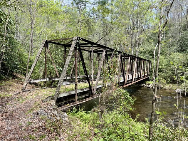
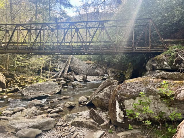
By 0925 I was pulling my pack out of the back of her SUV and saying my farewells. By 0930, I had that monstrosity strapped to my back and I was following the road over Fontana Dam and into Great Smoky Mountain National Park. 7 days of food is a lot, and I could feel the weight of my pack pressing down on my feet as they slapped the pavement—this was going to be uncomfortable until I finally put a big enough dent in that food bag. The Appalachian Trail and the Benton MacKaye Trail share the same route for about 3 miles, starting about 1.5 miles south of the Fontana Hilton, a massive hiker shelter with electric outlets and a spigot with potable water. Once inside the park, however, they split, with the AT heading straight up to the high country, while BMT meanders close to the lake for 30-odd miles.
The whole day was spent, pretty much, on old reclaimed roadbed—except for a few hundred feet of old reclaimed railroad track. The trail was wide and though I spent the day climbing up and down ridges, the grade was always easy. My pack wore on me, so that by the time I’d come to stop for a break my back and shoulders were crying for me to stop. I took lunch in the shade by a roaring river and dozed off leaning against my pack. Later, I came upon the Calhoun House; one of few remaining relics of a logging boom town that had come and gone a hundred years back. I climbed onto the porch, set down my pack, and peed into leaf litter below—which seemed to upset a duck floating the river across the trail, who scolded me with a stream of quacks until I was done. There were padded chairs on the porch, and after a quick snack, I dozed off there, as well.
The North Shore campsite has a name that would suggest a view of the lake. In fact, the lake is a good quarter mile or more beyond the camp, and all you can really see is a bit of an inlet. I’d had hopes of a lakeside sunset, but contented myself with a creekside dinner closer to my tent. I’d also hoped to enjoy the pleasant evening weather, but there was a full crop of gnats who were feeling much more friendly than I, so I hung my heavy food bag from the bear cable—a true luxury on the BMT—and headed into my shelter for the night.
Day 17: 15 April, 17.8 miles today, 228.2 miles total, Lower Forney Creek, Great Smoky Mountain National Park
Number of people seen on trail: 0
At the very stroke of midnight, something came crashing through the woods close to camp. I did my level best to scare it off, but whatever it was, it kept coming back every hour or two—and whenever I started using my most stern and loud voice, the creature would start huffing like an indignant horse. What the hell was this thing?
Shortly after dawn the commotion started up once again, so I stuck my head out of my tent to see if I could catch a peek of the culprit. Out of the corner of my eye I got a flash, but it was enough: the white upright arrow of a tail bounding into the underbrush. I’d been up all night being terrorized by a fucking deer.
As I started down the trail, hopefully leaving Shithead Bambi behind me, it occurred to me how few encounters with wildlife I’d had on the first half of the BMT, which in itself was a little strange considering that I’d been alone the entire time. I was just thinking that I should probably expect to have a few more run ins the farther I pushed into the park, when some large, dark brown shape took off a hundred feet to my right. At first I thought it was a small bear—the color was right, but there was something odd about the way it moved. Then it zigged to its left and I got a full view of its profile in the morning sun. It wasn’t a small bear, but a giant wild hog, the biggest pig I’d ever seen outside a state fair, and by far the fastest.
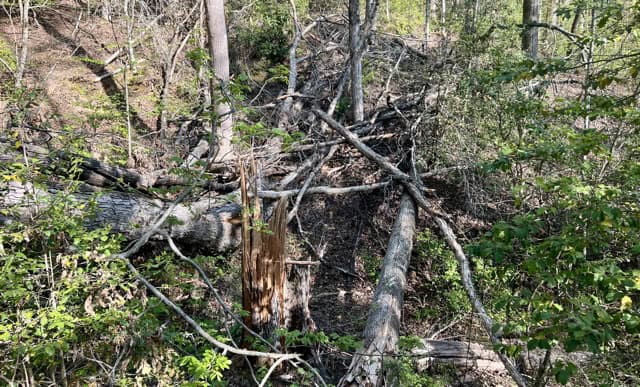
Judging by the elevation profile, this should have been the easy day of the Smokies. There were ups and downs, but nothing extreme from one camp to the other. What really started to drag on me, however—aside from the fatigue of a sleepless night and the spiteful sun of an unseasonably warm spring—were the blowdowns. Every mile there was some dead monster sprawled across the trail, and the only way past it was to climb. Usually, you don’t have to worry about obstacles like this so much in national parks. But then again, the Park Service had been gutted the year before, and doubtless there just wasn’t the staff to clear these things from the trail. This was a new America I was hiking through, and it sucked.
Worse than the blowdowns, though, was when the trail left the safety and comfort of the old roadbed and entered the long silk tunnel. Once again, I was plastered in spider webs from head to foot, wiping at them constantly from my skin. Some things get old fast; some things are old even the moment they begin. I was so sick of walking into all that I felt like I was losing my mind. There are only so many times you can catch a fully-formed web to eyeball before it starts to warp who you are as a human being.
(artist’s conception)
I was tired, sore, sweaty, and sticky with silk. Gnats and flies circles my head in a cloud, as I clambered up and over yet another massive fallen tree. Then the trail I was on abruptly ended at an intersection with a wide lane following the course of roaring Forney Creek. I had made it to camp, on the banks of a gorgeous rumbling cascade of mountain water. I quickly pitched my tent on a flat pad and headed down to water’s edge. As I washed the dirt from my legs and the sweat from my face, suddenly there was no other place on earth I wanted to be but this paradise, right here.
Day 18: 16 April, 16.7 miles today, 244.9 miles total, Burnt Spruce, Great Smoky Mountain National Park
Number of people seen on trail: 7
Every winter, Fontana Lake is brought down in preparation for the rains of spring. When those rains don’t come, as in the April of 2026, the water line remains far from the purported “shore,” the gaping scar this man-made feature has left on the natural landscape clearly visible where it would usually by now be underwater.
The lakes many fingers are actually ferocious natural rivers, tamed most years by placid surface of this massive reservoir. But in years such as this, when you can still catch a glimpse at at what much of the river basin once looked like before the dam was built, you are treated to a true spectacle. Forney Creek, as it gathers in volume and strength from all the other nearby waterways emptying into the same valley, becomes a roaring monster, the sort of violent, rocky, braided river you often only see at the retreating edge of a glacier during the peak of the summer melt. I heard the distant thunder of this churning mass of water the day before as I walked the last mile into camp, catching a peek of it here and there through the trees. What I hadn’t properly understood at the time was that this was to be my last glance at Fontana Lake on the BMT—from there the trail winds its way inland, and up into the mountains.
I had pulled a muscle in my right thigh scrambling over one of the previous day’s many DOGE-sponsored blowdowns—DOGE-downs I guess you’d call them—and spent the evening gently hobbling around camp, hoping that a good night sleep would take of it for me. Alas, no, the pain was still there in the morning, but it was easy enough to ignore, so I started climbing up toward the famous BMT tunnel. This was a hole blown through the mountain in preparation for a road which was never built. According to comments in my guide, it’s quite popular with tourists, as there is a parking lot at its far side, and it’s more often than not filled with the echos of screaming children. But not, apparently, at 0915hrs on a Thursday in April.
After a brief hike down a length of paved road, the trail turns onto a gravel road and begins a long climb up to Noland Divide. Gravel road walks are usually kind of boring, but I was happy to be bored after yesterday’s antics. After a couple of miles, I stopped to filter some water, and was passed by a family of 4, out on a day hike from the trailhead at the foot of the gravel road. I passed them again, and quickly lost sight of them as I headed farther up. The higher the trail climbed, the less road like it became, eventually narrowing over the miles to the usual rocky and rooty single-track belt you see in the Appalachians. I passed a backcountry campsite with three horses tied up to the hitching post. I saw evidence of one human at camp (one good bag, one tarp, one sleeping bag), but no one was around—despite the fact the campfire was still burning. I assumed the camper was nearby, but realized he hadn’t been when I met a man with no pack and no gear but a fishing rod, walking along the trail a mile from the fire he’d left unattended. His carelessness rather pissed me off—and the piles of horse shit he’d left on the footpath didn’t help—but it was nice that his train had cleared the trail of spider webs for the time being.
By the time I stopped for lunch, my DOGE’d-up leg was absolutely killing me. It was especially grueling on steep downhill sections, as if the muscle were being torn apart. I was starting to wonder whether I’d underestimated how badly it was injured, or maybe I’d just been making it worse by hiking on it all morning. I sat down for a long lunch at an empty campsite and let it rest a good while. By the time I was up and moving again, the pain had once again receded to ignorable levels—so I continued up.
Shortly, I ran into another backpacker heading south. He was doing a long trail of his own devising, hiking the BMT south to Fontana Dam, then jumping on the AT north to Davenport Gap—basically a big oval almost entirely within the bounds of Great Smoky Mountain National Park. It was a neat idea, and I wished him well, though his insight into the trail that lay ahead for me hadn’t been particularly helpful. “You got some climbing to do.” Well, yeah.
The campsite I’d gotten a permit for, I learned, had a history of problem bears. The last report from this spring had said that the site was reopened and everything was perfectly chill, but I knew that if I camped there I wouldn’t sleep but for a few fitful minutes here and there. So I figured I’d cut my day by a half mile and stay at the site before that one—the one after it being some 7 miles farther on at the top of a mountain. That left me plenty of time to get into camp, which I needed. My DOGE’d muscle was acting up again on the steep descent from the Nolan Divide, not helped by an apparently endless and increasingly complex set of rock-hopping/log balancing stream crossings.* About halfway down, I met another backpacker, with trekking poles in one hand and a fly-rod in the other. He spoke in a muffled mutter, like his cheeks were packed with cotton, and he was incredibly hard to understand. But I was eventually able to tell him, yes, it was very nice at the top of this climb, and no, I hadn’t seen any wild turkeys. He looked disappointed at this latter, which left me puzzled as I walked away. Was he a hunter, or just a turkey enthusiast? I hadn’t seen a shotgun strapped to his giant pack—and anyway, the last I heard, hunting was banned in all national parks. But, I mused as I walked away, a lot had changed in the last year. Who could say anymore what was against the law and what wasn’t?
*I did, in the end, manage to remain the president of the Dry Feet Club, but it took a truly ungodly amount of work.
Day 19: 17 April, 17.1 miles today, 262.0 miles total, Upper Chasteen Creek, Great Smoky Mountain National Park
Number of people seen on trail: 13
There is something about the midnight thunderstorm, always following a clear and mild twilight, that reminds you just how alone in the backcountry you are. It’s not fear, exactly—though lord knows that would have been justified enough after a storm on the AT, when a large branch snapped off a tree and smashed into my tent, missing my face by inches—but it’s just as primal. The tent keeps you dry, but you can feel how exposed you are, lying prone on the forest floor, the only human being in this valley, and for miles in any direction.
I cannot say I slept terribly well.
In the morning, the Smokies were as I remembered them from the Appalachian Trail: wet. The fallen leaves on the trail were dark and rich, giving off a pleasantly pungent woody smell with each footstep. Great pools of mist wafted along the valley floors as the sun brushed the crowns of the trees along the ridge tops. It was, all in all, a beautiful day to hike.
The day’s assignment was simple: one long giant climb, followed by a long, giant descent. I met two different pairs near the top—one set of friendly, genial women in their 60s who seemed to be friends, and a taciturn man and woman, also in their 60s, I assumed from their tip-to-toe identical backpacking outfits to be married. I was eating lunch somewhere along the ridge crest, with my tent spread out to the side to dry in the warming sun, when another hiker came along the same direction I’d been going. He shouted a merry hello without slowing—and he was hiking fast. He had the look of a seasoned through hiker, pack too large for a day hike, but compact, light, and economical for a backpacker. He looked to be in his early 30s, meaning that if he were indeed thru-hiking the Benton MacKaye, he was the youngest person on the trail by at least a decade.
The way down, in the heat of the afternoon, was a chore, a slog, a grind fest. My feet snagged roots and rocks and my joint were pounded into jelly. My DOGE’d leg howled in protest the longer I forced it to go on carrying me downhill, but I was set on getting grueling part of the day over with. At the bottom of the slope was a two-lane state highway, and across the highway was a campground. After speaking briefly with the rangers, they agreed to let me hang out on the air conditioned floor while I topped off my electronics on one of their outlets. We chit-chatted about backpacking and rangering, between interrogations from a steady stream of park visitors who all wanted to know what all those trees with the lovely white flowers were. “Dogwoods.”
They let me sit there until they closed up the station for the day. I headed up toward my allotted campsite, the one I’d selected and had a permit to stay at. I’d been wrestling with a dilemma—keep to the itinerary as planned, which would put me at the highest point of the BMT on a night forecast to be very wet and very, very cold, or push to get out of the park sooner, though I might risk running afoul of any backcountry rangers I met over the weekend. I got to my planned campsite with three full hours left before sundown, and that clinched it. I would push on, and see whether I could beat the cold snap out of the park. This was far from certain. It would mean finishing the last three big climbs of the entire trail in one day. But it might also mean spending a wet night in a shelter instead of a tent, and being safely indoors when the cold fell.
I made it to the next site up the trail with enough daylight to make camp and cook dinner. I was worried the place would be busy, but the only other people there seemed content to be camped out down closer to the creek than the proper campsite itself. It worked for me—I had a nice flat tent site, a fat sitting log with a flat stone for a table, and my own little brook, burbling happily away as the sun sank behind the mountains I’d crossed to make it here.
Day 20: 18 April, 14.7 miles today, 276.7 miles total, Laurel Gap Shelter, Great Smoky Mountain National Park
Number of people seen on trail: 2
I got up with the sun. I noticed as I was packing up my tent that a second food bag had appeared on the bear cables—presumably placed there by the person or persons camped down by Chasteen Creek. The pulleys on these things are usually weathered and rusty, so the fact that they’d gotten it up without my notice while I quietly lying in my tent was impressive. I set about putting together breakfast, looking over the miles I had planned for the day. When breakfast was done and the last of my gear stowed for hiking, I saw that the second food bag was gone. Whoever this backpacker was, they were sneaky as a mouse in a cat factory.
It may have been the young man who passed me an hour later, well into the day’s first climb. He was rail thin and extremely fast, his tiny ultralight backpack an afterthought on his shoulders. Whether he was BMT, I didn’t get a chance to ask, he was behind me, then he was gone, his cheerful good morning scarcely out of his mouth. I thought I might find him at the shelter at the end of the day, but who knows—he might have made it all the way out of the park by sunset, the way he was moving.
When I’d cleared Hughes Ridge, my first mountain of the day—all the way up one side and back down the other—I sat down for a snack at Enloe Creek, a thundering waterway which cascades past moss-carpeted boulders, lining its banks like a canyon built from the valley floor up by a very, very, very large child. How remarkable was this green, majestic place, hidden from the outside world by all the hard miles. These lofty wooded peaks and sun kissed valleys seemed almost as if they’d never the hand of a single human—an impression broken only by the trail I was walking and the occasional bit of infrastructure built to support it. This wasn’t the Smokies of the Fontana shoreline, with its relics of an age passed by a hundred years before. This was something far, far older, urgent, expansive, and wonderful.
I was about 2/3 of the way the day’s second mountain when my DOGE’d leg caught up with me. I took a maximum strength dose of Vitamin I, but the wind was gone from my sails. The walk down Hyatt Ridge was a pitiful exercise in mountain walking—or so it felt at the time. Though it felt like it took all day, in truth I was settled on a broad, flat rock and having lunch in the shade not too long after midday. After a short break, the pain in my leg once again felt manageable, so I began the long climb up to Big Cataloochee Mountain, where the Balsam and Sterling ridges converge.
The was the climb people had been speaking about in hushed tones ever since I’d started the BMT. And it was arduous, but not quite the unconquerable ascent it had been made out as. After 90 sweaty minutes, I sat down in a small pine grove to cool off in the shade, but discovered once I started moving again that I needn’t have bothered. The trail had come up the slope to a broad pine forest, bedded with countless little white flowers literally abuzz with equally countless bees. The air was blessedly cool in this shaded wood, and a slight breeze cooled the sweat still running from my brow. The grade eased, and the path meandered through mattresses of moss and pine needles. It was like a mountain out of Vermont, cool and green and quiet.
The trail dropped into a saddle, and the pines became mixed with rhododendron and mountain laurel—though it was too early for either to be in bloom at this elevation. I was approaching the high point of the BMT, though I wouldn’t reach it until the following day. Still, at 5400’ this would be the highest night I’d spend on trail, and probably the coldest.
The AT famously has shelters every six to eight miles for the entirety of its 2,193 mile run. The numbers on the Long Trail are similar. The BMT has only two: one in the weird stretch of trail through the gated cabin community outside Blue Ridge, GA, and the one at Laurel Gap, on the east side of the Smokies. I’d been worried it would be overcrowded, full of backpackers with the proper permit, and anyone else on the mountain looking to avoid tenting in the night’s promised rain, but it was empty. It stayed empty while I fetched water and made dinner, and stayed empty when I made my bed for the night. I’d slept 16 nights so far in the wilderness, every one of them alone.* In that respect, this one would be just like the others, but this time I’d be in a shelter, and just a short** walk from the end of the trail.
*I did not feel that the previous night counted—while there was technically someone occupying the same backcountry site I was on, they were far enough away that I could neither see them nor hear them.
**Not really
Day 21: 19 April, 12.0 miles today, 288.7 miles total, Baxter Creek, Great Smoky Mountain National Park
Number of people seen on trail: 3
On the last day, it snowed.
Sort of.
There is an intensely cozy feeling to being in a hard-sided structure with a fully-functional roof while it’s raining. The sound isn’t all that different from the TATTATTATTAT of rain falling on your tent, but the context makes all the difference in the world. Rain always wakes me up in a tent. In the Laurel Gap shelter, I lay tossing and/or turning on the thin foam pad “cushioning” me from the hard wooden platform, staring up at the darkened ceiling and listening to the baying of wild dogs somewhere not too far down the mountain—until the rain began to fall. The white noise of a thousand drops hitting the corrugated roof swaddled me like a thick, heavy, loud blanket, and I dropped right off to sleep.
The rain came in furious bursts throughout the night, sometimes no more than a spatter, sometimes a downpour lasting an hour or more. I wasn’t really aware of it until it stopped, still a couple of hours from dawn. I woke up because I was cold. The comforting sound of the rain had been replaced by a steady rush of wind in the treetops above the shelter, and though only an occasional gust made into the building itself, the ambient temperature had dropped. I pulled my head inside my quilt and cinched it closed, warm enough in my little portable down cocoon to sleep fitfully until the morning.
I poked my head out shortly after sunrise to a world transformed. The shelter’s interior was the same as ever, but everything outside was coated in a thick layer of frost, like a forgotten ice cream sandwich at the back of the freezer. Every leaf on every tree, every pine needle and blade of grass, even my food bag, were all white. It wasn’t snow, but it lay like it across the earth, thicker than any frost I’d ever seen before. Knowing there was no point in waiting—it would be more or less as cold in a hour as it was at that moment—I crawled out of my quilt and into every stitch of clothing I had with me, hiking shorts and shirt, socks, long johns, long-sleeve shirt, hiking sweater, rain pants, rain jacket, hiking shoes, fleece-lined hat. I had to wait to put on my gloves until after my coffee was ready, and my fingers burned in the cold as I put everything together. It helped that I didn’t have to break my tent down and put it away, but also you work fast in the cold. With the overcast sky barely at full light, I was ready to walk.
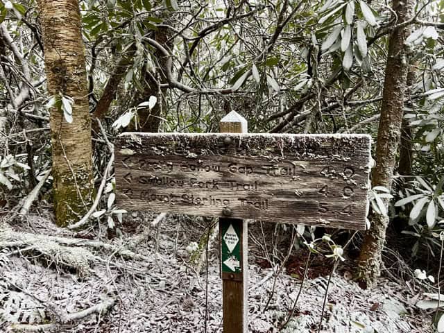
Along the crest of Sterling Ridge, I was essentially in the clouds. Ice crystals flew steadily through the air on a constant wind, and even hiking in every layer I was still uncomfortably chilly most of the time. The scenery was a line drawing on an empty page, with no hint of a background through the frost-laden trees, but still the trail itself was clearly visible as a meandering line of brown through the white-carpeted forest. There were moments that were almost pleasant, serene a postcard-perfect, with only little streams to break the silence. Other times, the ridge narrowed, exposing the trail to the constant blast of icy wind blowing up from the valley below. The lines of spider silk that had been set for me across the trail were all coated in ice, making them clearly visible and easy, for once, to avoid. The footsteps and miles blurred together into a white mush as I drove on to the summit of Mt. Sterling, the high point of the BMT, the last climb of the trail, and what was originally supposed to be the site of my last camp in the Smokies.
Probably there is nice view up there on good days, but this wasn’t one of them. Nothing by the same stinging wind and inside-cloud view of the rest of the ridge, with a backpacker standing beneath the old lookout tower bundled, like me, in apparently everything she owned, taking a video of herself on her phone. Whether she saw me approach on her screen or heard the crunch of my feet on the frost I don’t know, but she seemed embarrassed that I had walked in on her recording a selfie and anxious for me to move on. Any other day I would have stopped to savor the moment—the last peak, the highest point, blah blah blah—but today I was just cold and was only too happy to indulge her desire for solitude. Or, not solitude, exactly, since I assumed the young man walking up from the water source wearing crocs and a full-sized wool poncho* was there with her. Whatever this couple of excited weekenders could want from freezing-ass, sleet-pelted peak was beyond me, but I wished them well and made for lower, and hopefully warmer, elevations.
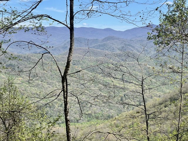
It was a long, winding walk from baleful Mt. Sterling to the trailhead at Baxter Creek, but quite lovely in its own way. The frost offset the moss and lichen coating the rocks and trees in an otherworldly way that almost made them seem to glow. I was amazed how far down it stretched—I had dropped almost two thousand feet before I worked my way beneath the clouds. From here, I could catch glimpses through the trees of the vast valleys and high sloping ridges that lay beyond the one I was walking down, and the sunlight that had slanted under the high clouds had melted whatever frost there had been in the trees above into sporadic bursts of drops that fell at odd intervals from above. Here, I was able to stop and de-layer, pausing long enough to eat a joyless protein bar and retie my shoes. I still had two thousand feet more to drop, watching the climate warm the lower I got. Pines gave way to massive oaks and long tunnels of Rhododendrons, and began to see dozens of a strange, massive, fat-bottomed beetle, two inches long and black, but with a mesmerizing blue nacreous sheen to their bodies. It was a different world down here, still not warm, but chilly in a way that felt temporary. This was a place accustomed to heat, and which seemed to expect to feel the sticky warmth of the American southeast again, and soon.
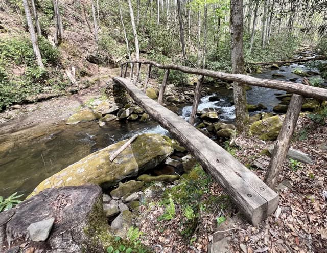
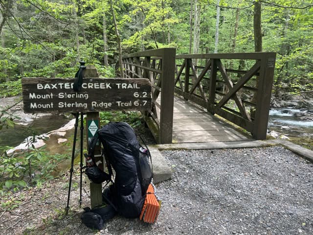
The trail leveled out as the sound of Baxter Creek grew loud and boisterous enough to hear over the rusting of all the green new leaves in the wind, and I passed the only day-hiker I saw on what had become a crisp and perfect morning. Where the creek meets the BMT it is wide and flat, but no less a wild Smoky Mountain canyon cutter for its girth. Tumbling over rocks, it roars beneath the thin iron footbridge that delivers the trail-beaten thru-hiker from the heart of the Smokies to the outer edge of civilization—which in this case is a poorly-maintained** trailhead/picnic area at the end of a mile-long dirt road. The Benton MacKaye Trail, unknown in almost every community it crosses or nears—unknown even among the hikers of its nearby big sister, the AT—ends with as little notice or fanfare as it lives along its 289-mile spine. On the civilized side of the footbridge, maybe 20’ from a wheelchair-accessible picnic table, is a small, weather-worn trail sign which reads:
BAXTER CREEK TRAIL
Mount Sterling 6.2
Mount Sterling Ridge Trail 6.7
On the wooden 4×4 below this is a small green sticker emblazoned with the BMT’s white diamond logo, small enough to miss at a causal glance. If I hadn’t known in advance to look for it, I would never have seen it at all. This says simply:
Benton
MacKaye
Trail
Northern
Terminus
It was an anticlimactic end, but hard earned. The unforgiving slopes of the southern Appalachians had broken me just a few years before when I had come to them without humility and ill-equipped. I’ve thru-hiked the AT, I thought, I know what I’m doing here. I was out of shape, slow, and unprepared for what those cruel pinnacles of earth and stone would do to my joints in that condition. I’d never spent a night in those mountains in the fall, when the streams have stopped flowing and the springs have dried to shallow puddles. The BMT I’d returned to had been just as dry, though this time due to drought instead of season, but I’d at last come prepared to harvest and carry water. I’d come prepared for the solitude, the long and grueling climbs in the blistering southern sun, the nights spend with god knows what lurking through the underbrush. I’d come once more to this trail humbled, the memory of how easily it could throw me off its steep pitches and wooded ridgelines still aching in the back of my mind. I’d come ready to give the trail the respect it deserved. I’d come, at last, prepared to deal with pretty much anything the Benton MacKaye had to throw at me.
Except the spider webs. God damn the spider webs.
*Which, okay, sounds like I’m sort of just describing a serape, but this thing was not only uniformly gray, but had the blousy fitted shape of the sort of plastic poncho you’d find in a gas station, and not the colorful blanket-looking thing Clint Eastwood used to wear.
**Like the trails through the park itself, this neglect seemed recent—and presumably DOGE-related.