Day 10: 08 April, 15.3 miles today, 141.2 miles total, Moss Gap, Cherokee National Forest, NC
Number of people seen on trail: 1
I was sitting in the TelliCafe of Tellico Plains, working my way through a wonderfully overlarge slice of peanut butter pie and downing my fifth cup of coffee, when I realized I recognized the song that was playing on the restaurant’s sound system. It was “Blinding Lights,” by The Weeknd—except this wasn’t the The Weeknd, this was some easy-listening cover, a version of the same thing meant to make it more palatable and easier to ignore.*
I was thinking about this I lay in my trailer bed, having just learned that Tellico Plains is the home of the Patriot Front, a neofascist, white supremacist, paramilitary gentlemen’s club. This is a group that openly declares—along with all the usual boring bigoted bullshit you’d expect—that democracy is a failure, and fascism is the solution. This, I realized, was the original club banger, The Weeknd version, with all its semi-soft hard edges intact. Meanwhile the anti-democratic legislation then being pushed by mainstream fascists like Mike Johnson—who appears to be what would happen to Ned Flanders if he shaved his mustache and then sold his soul to the devil—is the easy listening cover, a version of the same thing meant to make it more palatable and easier to ignore.
Though of course, the light version never does go hard enough for rabid fans of the original.
But you can’t learn that the very small town you’re in is the epicenter of an organized mob of angry, hateful incels without it influencing how you see the place. Every face I saw the next morning, I wondered are you one of them? I needed to get the hell out of that town, but I had only one way to get there. Are you one of them? I asked the driver of each lifted pickup as they blew by my extended thumb. The man who did eventually stop for me was almost certainly not a member of the Patriot Front, but he was a reminder that any crop, no matter how noxious, needs fertile soil to grow.
Every hitch I’ve ever gotten began with a short conversation through an opened window, but when the pale blue Camry pulled into the shoulder, the driver just motioned for me to get in the back seat. I got in and the driver turned to face me. He looked to be in his fifties, with a thin face and short mustache under his graying mullet. All the windows in the car were rolled up as the man took a drag from his cigarette and said, “I’m Thomas. This here is Taylor,” he said, motioning with his lit butt to the man in the passenger seat, “and how are you?” I gave him my name and he asked me where we were going. “There’s a hiking trail about 16 miles down this road.” “The Benton Trail,” he said, “yeah, I know it. All right, then.” It was reassuring to me that he knew the trail well enough to get part of the name right. All right then, indeed.
He floored it and the little sedan took off, screaming down the winding road so fast Thomas had to drive on the shoulder to take the curves. When the road straightened out for a bit, I caught a glance at the speedometer and saw that were holding at 80mph. He apologized that his voice was rough, “like Wolfman Jack,” he said, but Wolfman Jack had been much easier to understand. Thomas sounded like Wolfman Jack with strep throat, and he talked constantly, but I only caught the gist of most things he said. He wanted to know if I was saved, if I wanted to smoke a joint, and how many guns I had. “There’s and uprising coming,” he told me, “and I’m gonna lead it.”
For the most part, Thomas and Taylor while I sat in the back seat trying to follow the discussion. I couldn’t figure their relationship out—they obviously knew each other, but not well, it seemed. Were they related? Coworkers? Had they met at church? Their topics of conversation didn’t much help. Somebody had needed to be beaten unconscious, but afterwards had learned his lesson. What this area needed was a restaurant that served up real country food. And, just as I was starting to space out, “I ain’t no queer, but you do have some of the most beautiful eyes I ever seen.”
It was a huge relief when we got the trailhead and Thomas pulled the car over. My concern was less that I might be kidnapped, and more that the two guys up front would talk themselves into the sort of side quest that can derail an entire day while I was still stuck in the back—trying to source the weed to roll that joint, for example. We all got out of the car, and I shook their hands, quietly ashamed at the way I’d lowkey judged these men and let myself constantly assume the worst. They’d just done me a huge favor, after all, with no expectation of a reward. Whatever vileness might lurk in the dark corners of their hearts, I couldn’t much say, because all they shown me was kindness, for which I owed them gratitude.
As I gripped Thomas’s hand, he squeezed mine in a steel grip, a powerful, bone-crunching handshake. But he was smiling. I thanked him for the ride and he said, “no problem at all!” Then he leaned in. “I’m a warrior for the lord.” With that I left them, and marched into the woods.
*I actually quite like this song, but hadn’t realized it had had any hard edges to remove in the first place. As it turns out, this soft-rocking megahit could become a great deal softer still.
Day 11: 09 April, 14.1 miles today, 155.5 miles total, Sycamore Creek, Cherokee National Forest, NC
Number of people seen on trail: 0
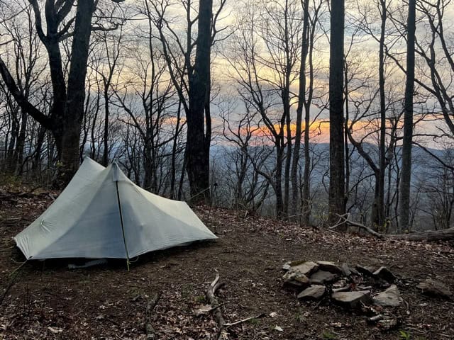
The wind started at sunset. It came on full blast, as if a switch had been hit somewhere down in the valley below. The sturdy little tent was buffeted all night but held up without issue—and if I was totally cozy bundled up inside my quilt, I was, at least, cozy-ish.
I awoke briefly in the pre-dawn twilight with the perception that something was different. It took me a moment, but then I was able to identify the sound: silence. The wind had stopped, apparently, as suddenly as it had started. Nice, I thought as I drifted back off for another hour’s sleep, it won’t be so cold when I get up.
It was as I was getting dressed an hour later that the switch was flipped once again, and the wind came rocketing back over the saddle on which I was camped. It was too windy to make breakfast, too windy to go dig a cathole. Just too damn windy. A gale is always unpleasant, but it’s also stressful when you’re trying to break down your one and only shelter on this wilderness excursion without turning it into a sail that can be ripped out of your hands and lost to the elements. When I finally had everything stuffed into my pack, I backtracked down the trail until it had dropped far enough that the ridge I’d been on became a sort of windbreak. There wasn’t room on the slope to spread out, so I unpacked on the trail and made my breakfast there, hoping no one would come along.
Nobody did, and soon after starting up for the day I was making my way along a winding ridgeline, peppered at every low point with overgrown thorn bushes. They looked like blackberries to me, and would be a treat worthy of the trail’s obscured and uncelebrated halfway point for some lucky hikers in about four months. For now they were just a continual nuisance that left my legs scratched and my mood grim. Eventually, the trail made its way down into a valley, crossing a wide, freezing cold stream several times without the aid of stepping stones. I was surly about having to take off my shoes and socks (or else be left with sodden feet the rest of the day) but I did have admit after drying my tootsies over lunch that they did feel much better for their cold baths.
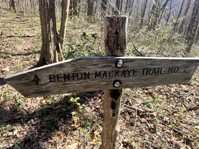
After lunch, the trail wound up the valley’s far side, and things were going well until I came to a sign beside the path that said “Benton MacKaye Trail” with a single arrow pointing back the way I’d come. I stopped and looked around. There was no other obvious trail but the one I’d been on, so I continued forward around a wide bend, where I was met by a massive blowdown blocking the trail ahead of me. I could just past it that several more downed trees lay across the way, so the best course seemed to be to divert down the drainage I was standing over and come up the other side. I was delicate precarious business, finding footing on steep terrain under and foot and a half of fallen leaves, but I made it up the other side without serious incident. It when I then went to double check that I was still going the right way that I discovered that I was off course. I was supposed to have turned somewhere by that damned unhelpful sign.
Hot, sweaty, frustrated, I had a choice: I could backtrack the way I’d come and recross that terrible drainage I needn’t have crossed in the first place, or I could bushwhack up the slope and try to meet the trail up ahead somewhere. I made the worse choice, and so spent the next thirty minutes fighting my way through briar patches, rhododendron shrubs tangled with broken branches and thorny vines, and dead and rotting logs, all blanketed with piles of leaves over the vicious and steel upslope. Eventually I spilled into a small clearing, and could see the trail right in front me, a smooth and gentle pathway carpeted in neat layer of grass. I checked the map again. After all that time and effort, I made it all of 0.1 miles past the junction I’d missed an hour before.
A couple hours later I sat at a trailhead, on a broken picnic table set by the roaring Tellico River. I’d only meant to stop for a quick snack, maybe five or ten minutes, but once sitting I’d found it hard to get moving again. I was exhausted from the day’s shenanigans, my arms and legs a matted mass of dried blood and forest debris. I was trying to convince myself to go one mile farther before calling it a day, and bit by bit I was succeeding—though the river was mesmerizing. This section of the trail had proven to be grueling in a way the previous 150 miles hadn’t been. I closed my eyes and listened to the water churn and cascade over the rocks. What trials would the next day bring? And the day after? And the day after?
Day 12: 10 April, 16.7 miles today, 172.2 miles total, The Hangover, Joyce Kilmer-Slickrock Wilderness, Cherokee National Forest, NC
Number of people seen on trail: 2
My legs were so scraped, scratched up, and ruined that I awoke with a jolt each time they touched. So, even though the nights were finally starting to trend warmer, I pulled on my long johns and slept the sleep of the thoroughly hiked out.
I had assumed that the morning’s long climb up to Little Haw Knob would be a breeze. True, this would be the first time the BMT made it above 5000 feet, but the grade looked so genial I figured I’d have it licked by the time I stopped for my mid-morning break. Instead, midday found me just coming to the crest of the ridge—I’d been pushing for hours, but was never able to get my speed up. I ducked down to a pond to fill up on water before pushing on along the top of the dry ridge.
For most of the afternoon, the trail hovered above a mountain highway popular with motorcyclists—sort of the way the AT mirrors Skyline Drive through the Shenandoah, but in reverse. Every so often, I’d hit a stretch of reclaimed road, and for a mile or so the path would be wide, even, and fairly flat. But for the most part, steep climbs and sharp descents ruled the day.
Toward late afternoon, I veered a quarter mile downhill from the BMT toward what would be the last reliable water source for several miles—and for the rest of that day. Here, the distinction between “reliable” and “good” became apparent, as I sat next to a mud puddle and let my makeshift scoop slowly fill with drops, as the sun inched ever closer toward the horizon. Eventually, i had all the fresh water I could carry. I made my way toward the day’s last climb, and stumbled through the camp a pair of young men had set up immediately beside the trail—and overlooking a break in the forest that gave out on a truly stunning view of the peaks and valleys to the east. I remembered suddenly that it was Friday, and that for the next couple of days I could expect some degree of company in the backcountry. The guys were friendly, but their dog was not, despite her owner’s assurances to the contrary, so I moved on.
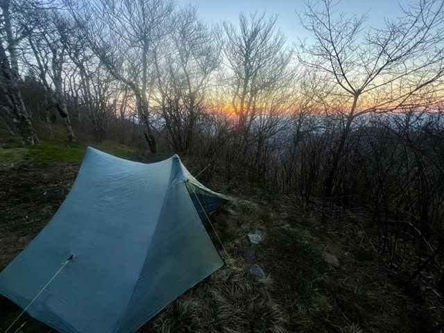
The last climb was a true motherfucker, an asskicker short on mileage but heavy on vert. It was a true New England climb, hand over hand, but through the Southeastern briars that had been encroaching more and more on the trail the farther along it I’d come. I’d been holding onto a secret hope that I come over this last peak with the time and energy to push on farther down the mountain, but once I again I was toasted, to tired to keep going—especially into this kind of terrain. And so I walked out along the ridge until I found a small grassy cove amid the stunted and gnarled trees that seemed as if it might be sheltered enough from the wind to keep me cozy for the night. But on top of any Appalachian ridge, especially those north of 5K’, that’s always going to be a gamble.
Day 13: 11 April, 15.8 miles today, 188.0 miles total, Yellow Creek Mountains, Nantahala National Forest, NC
Number of people seen on trail: 4
I was already tucked into my quilt for the night, watching the sunset pink clouds drift beyond the mesh screen of my tent, when the trio of young weekenders arrived at the Hangover. I first noticed them coming along the ridge when I heard the tinny, intrusive discharge coming from their fucking bluetooth speaker.* But then I heard one of them say, “Oh shoot, there are already people here,” and the music was blessedly silenced immediately. They spent some time discussing their next move, as I had already pitched my tent in the most prime of locations, but they decided to spend the night another few hundred yards farther on, presumably sleeping on the scenic outcropping for which that bit of the mountain had been named. At any rate, I never actually saw them.
I awoke just before the sun broke the horizon to the low percussive beating of a ruffed grouse. You hear this sound a lot in the lower Appalachians this time of year, and if you aren’t used to the quickly-increasing low thudding coming from the brush—FROOMP FROOMP FROOMP FROOMPFROOMPFROOMPFROOMPFROOMP—it can be spooky; it sure doesn’t sound like it’s coming from a bird the size of a miniature turkey. Once you know it’s just a thunder chicken beating its wings, though, it’s a pretty neat way to wake up, especially with a mountaintop sunrise to set the mood.
It was Saturday morning, so I wasn’t completely surprised when I met a couple of day hikers as I was picking my way along the hellaciously steep slope down to the dirt road at Big Fat Gap. The sun was high and hot by the time I made it there, so I yardsaled everything in my pack on a flat, dry patch of ground—everything that morning, including my down quilt, had been absolutely sodden with early morning condensation. Why all my earthly good were baking in the sun, I set out to find a hidden corner of the woods to dig a cat hole. But such was the steepness of the terrain that the only places flat enough for pooping were clearly visible from both the parking area and the network of trails that converged there. Still, there didn’t seem to be anyone around. I’d just have to hope no random hiker rounded a bend at an awkward moment.
Most weekends on most trails, a thru-hiker can count on company in the mountains—sometimes the presence of clean and perfumey strangers is the only way you know what day of the week it is. Usually it’s something of an annoyance, the semi-pro walker’s version of rush hour, but on the BMT I’d have traded my last fistful of peanut-butter m&ms to have had someone out there to walk the gauntlet of spider webs ahead of me. The closest I came was a friendly couple lazily breaking camp in the late morning, but they’d clearly been parked where they were long enough to have had no effect on the long, unbroken silk tunnel. Where the hell was everyone?
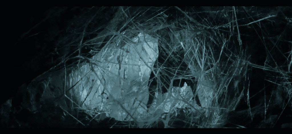
(artist’s conception)
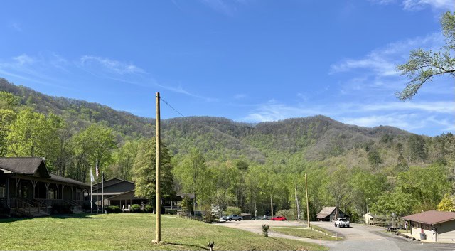
At the Tapoco Lodge, it turned out. This was the third restaurant directly on or near to the BMT, and since the odds of my running across any trail magic on this unknown route were nil, I was determined to get a hot meal at every one. The grounds felt eerily deserted as I tromped down a steep bank and was spit out onto a paved road, surrounded by cabins that all seemed to be empty. But as I got closer to the riverside lodge itself, I was overwhelmed by the constant buzz of human activity. Car, trucks, and motorcycles were in constant motion through the sprawling parking lot, with a half-dozen attendants directing traffic. Careful not to get run over in this maelstrom of metal, plastic, and glass, I walked into the lodge and followed a massive sign that said simply “EAT,” which lead to a sort of Ethan Allen style banquet hall. There were people here, each with platefuls of food in front of them, but no servers or hosts to direct me to a table. One the diners looked me over, sweat stained shirt, skin still glistening with sun screen and littered with spider webs and forest debris, my rank and filthy pack hanging on my back with my trekking poles in my hand and a bemused expression on my face. “Are you here for the toyota prius convention?” Sure, buddy, the only prius conventioneer who walked four days through the woods to get here. “Uh, no. Is there, like, a restaurant in this place?” “Yeah, out the back and the down the stairs.”
Downstairs, there was a 90-minute wait for seating my the Tapoco River, but none for a seat in the air-conditioned building next to a wall outlet, and soon I was working my way through a ridiculously large burger and full-sized salad, while quietly filling my water bottles from the carafe on the table.
Clear, roiling rivers in the mountains do indeed make for scenic locales to stick a place to get a nice, pricey meal—they also carve sheer walls into the surrounding rock. I’d followed the gradually descending drainage of the Yellowhammer Branch for miles down to the Lodge, but I was leaving up the sheer western face of the Yellow Creek Mountains, and with a tummyful of meat and beer weighing me down. Getting up onto the ridgeline was an agony of muscle and sweat, my calves screaming within the first few steps, and for a couple of hours I focused on nothing but the climb. I was anxious to have this part out of the way before worrying with the trivial detail of where I’d spend the night. I wasn’t until the grade evened out and I took a closer look at the topo map that I realized how narrow the ridge was—just a narrow hump with a sharp drop on either side that continued the entire length of the range. Well, I figured, there will be a campable site on one of these saddles or peaks. I’ll just keep walking until I get to one and call it day.
Except that I didn’t. There wasn’t a single flat patch of ground big enough for a tent anywhere in all the miles of the ridgeline. I didn’t even call it a day—nature did it for me. I’d just reached another fruitless peak as the sun was rubbing against the jagged alpine skyline to the west. I’d run out of day, and would lose the last of its light in maybe 20 minutes. I idly brushed spider silk from my arms, and it occurred to me that if I hadn’t seen a single backpacker on this trail all day long, the odds of anyone tramping down this route after dark we’re close to zero. With that, I pitched my tent on the trail itself, and collapsed into the encroaching darkness.
*I don’t care what your reasoning is. These things belong in the wilderness exactly never.
Day 14: 12 April, 6.8 miles today, 194.8 miles total, Fontana Dam, Fontana Lake, NC
Number of people seen on trail: 2
One of the maddening quirks of insomnia is how random it seems to render the correlation between physical exhaustion and sleep. I had worn myself out pushing on to a camp site I’d never found, but spent the first long hours of the night staring at the roof of my tent. It was only in the deepest, quietest part of the night that I finally and properly fell asleep. But that didn’t last for very long.
CRUNCHCRUNCHCRUNCHCRUNCHCRUNCH. Something was outside my tent, jogging around my ersatz campsite. “Hello!” I yelled into the darkness, but it didn’t seem to make a difference. CRUNCHCRUNCHCRUNCHCRUNCHCRUNCH. Now I roused, fully awake and on edge. “WHO IS THAT? WHAT ARE YOU DOING OUT THERE?” I bellowed. A sound came from just outside the tent, a couple of feet from the back of my head. It was only for a second, but I had the distinct impression of a dog’s rapid panting. Then it was gone, the faint crunch of a fast animal already well down the mountainside echoing in the distance. It could have been a coyote; I’d been seeing more and more trail poops that would have matched. My biggest concern when I’d been struggling through the fog of sleep was that it had been an escaped farm dog with a questionable temperament. This was also possible, though I’d never know. When the light of day finally broke over the mountains, there was no sign that my visitor had ever been there. And after hastily filling my pack, there wasn’t a sign that I had, either.
And in 0.2 miles, about five minutes farther up trail atop the next peak in the chain, was a perfect, flat, clear, wide, and open camp site.
From the dry Yellow Creek Mountains, the BMT drops down to skirt the property of Fontana Lodge for a few miles. It even passes the front door of the big building housing the large restaurant with an all you can eat breakfast buffet. AT hikers hire shuttles to come to this place, but the Benton MacKaye delivers it to you on a silver steam tray. The lodge is airy and clean, and the food quite rich and plentiful, which makes stepping back onto the trail all the more disappointing. It feels less like a trail where it runs by resort property and more like a narrow lawn that’s been left to be taken over by the sharp, grabbing thorns that have claimed the right of way. By the time your breakfast free-for-all has been half digested, though, you’ll have climbed onto a network of old, repurposed dirt roads. These last miles before the BMT rejoins the AT at the edge of the Smokies are easy, a pleasant walk in the forest, shaded by the thick canopy as clear streams burble beside the path.
The Appalachian and Benton MacKaye Trails merge about a mile from the AT shelter at Fontana Dam, itself about a mile and a half from the boundary of Great Smoky Mountain National Park. The 93 miles the BMT spends meandering the park’s interior are the last of the trail, and before I would start across I’d need to rest and resupply. I’d made arrangements with a local hotel that caters to hikers before I’d even started hiking. Now that I’d come to the edge of the ending, all I had to do was send the proprietor a text that I had arrived. A half hour later, I was in my room’s small standing shower, letting the hot water wash the hard and dirty miles from my legs.
Day 15: 13 April, 0.0 miles today, 194.8 miles total, Robbinsville, NC
Number of people seen on trail: N/A
This attempt at the Benton MacKaye Trail was the first time I’d ever set out on a long distance trail with the last footsteps scheduled in advance. I’d wanted to meet my parents at the trails end, and tie a small camping trip in the Smokies into the whole endeavor. That area is exceedingly popular—Great Smoky Mountain National Park, in fact, is the most visited park in the United States*—and sites in and around the park book up far in advance. Which meant that one of the first steps in planning the logistics of this hike was planning the camping trip with Mom and Dad. With that set, I could build an itinerary for my Smokies backcountry permit. Then all I would have to do was walk into the park.
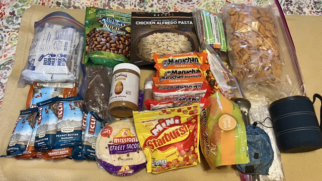
Except that I’d been hiking faster than I had planned on, reaching the park border about a day and a half sooner than I’d expected. All this really meant in practice was that I’d been gifted a zero, an extra day to hang out in a cozy little mountainside hotel that catered to thru-hikers. A day of catching up on town chores and lounging on the queen sized bed in freshly laundered clothes. An extra day of tv and town food. A full day to relax before I’d have to strap on a pack loaded down with six and a half days of food and head back into the wilderness, to the end of the Benton MacKaye Trail.
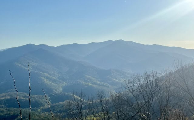
The northernmost 93 miles of the BMT run from the southwestern corner of GSMNP to a trailhead in the middle of nowhere along the park’s northeast border. This greatest and most wild section of the trail is often described by many thru-hikers as their favorite, and no wonder: The Great Smoky Mountains comprise a rugged, forested sawtooth formation of great sweeping slopes, high lonely peaks, meandering ridgelines, and deep emerald valleys, home to most of the tallest mountains east of the Rockies.** The entire range is situated within the Appalachian temperate rainforest, one of the wettest places in the continent, as well as one of the most biodiverse regions on earth, with many species found nowhere else on the planet. The hardwood stands beside the swollen creeks roaring their way through the bouldered valleys abound with wildlife, where the noise of countless native species chirping, croaking, whistling, singing, cawing, and howling is constant; while the spruce-fir forests of the higher elevations are quiet in a special, muted way that makes you feel like you’re sitting in church with a blanket over your head. It’s a glorious and green place, holy to the Cherokee who once lived among these spectacular peaks and to the backcountry hikers who now wander the wild and empty land. I couldn’t wait to return.
*It’s not even close. While Zion, Yellowstone, and Grand Canyon battle it out each year for second place with visitors in the 4 millions, GSMNP numbers are consistently over 11 million—almost as much as those next three combined.
**Though the highest, Mount Mitchell—which Benton MacKaye tried desperately to include in his masterpiece, but couldn’t due to the impenetrable and pervasive long trail management problem of private land ownership—is a part of the nearby Black Mountain range.
Always a great read