Day 0: 29 March, 8.4 miles today (none on the BMT), 0.0 miles total, Springer Mountain Shelter, Springer Mountain, Chattahoochee National Forest, GA
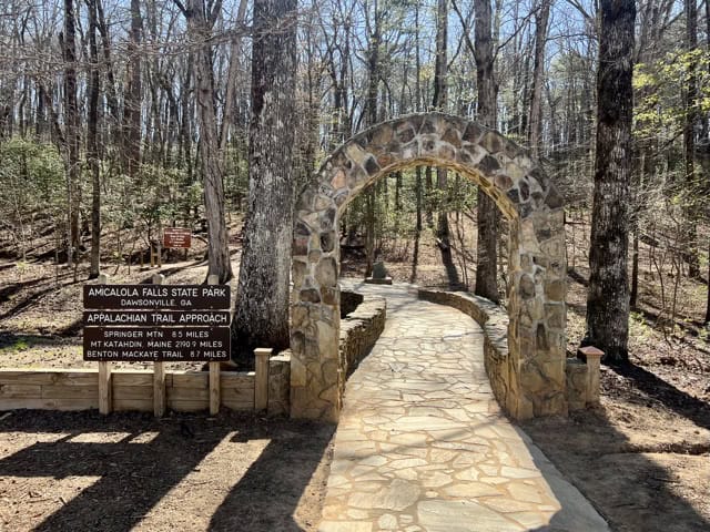
The AT approach trail is no fucking joke. After lallygagging for an easy half mile past the narrow parking spaces that line the valley floor from the start of the trail to the in-scenic picnic area by the base of Amicalola Falls, the trail heads straight up. The two winding staircases that cover the next half mile comprise some 600 steps in total, and will take the wind from all but the most psychotically fit of trail runners. From there the terrain lightens up to only moderately severe, following the continual rise and fall of the forested mountains for the next seven and a half miles. The Approach Trail is a swift and heavy kick in the ass, a brutal welcome to the Appalachian Mountains that many AT (and BMT) hikers avoid by getting a ride up a treacherous dirt road that wends its way past a small parking lot on Springer Mountain’s northern slope.
But Amicalola Falls is an easy 45-minute drive from my parents’ home. The rolling farm country makes for very pleasant scenery once you make it out of their suburban town, an air-conditioned nightmare* to the northeast of Atlanta. I’d wanted to keep things simple for them on the morning they dropped me off to retry the Benton MacKaye Trail, but I think there was an element of superstition, as well. I’d hiked the Approach Trail when I’d made my successful attempt to complete the AT, but when I bailed on the BMT after only thirty-something miles, I had not. That had a lot more to do with the shape I’d been the last time I’d tried it—as well as—the cold and shadowed time of year I’d tried to do it in—but I figured an extra day in the woods might nonetheless do me a bit of good. And if the stars were to align for this new undertaking, that would be all to the good. And they seemed to be doing just that: I got into Georgia with just enough time to be trail-ready by 28 March, the anniversary start date of my inaugural thru-hike, nine years to the day after my dad had last dropped me off at the Amicalola visitors’ center.
Except, that also happened to be the day of third No Kings protest. And while as a jaded middle-aged man I could look back on all the miles marched in my youth against a war that never once seemed to slow down on our account, I nonetheless could not betray the version of myself who believed with all my little soul in the power of a critical mass of human beings to change the world around them by the sound of their collective voices crashing through the canyons of the cities, screaming, “WHOSE STREETS? OUR STREETS!”

Obviously it’s not that simple. But if all my youthful zeal accomplished vanishingly little, the years of morose apathy that immediately followed accomplished absolutely nothing, and if a single vote has the potential to influence the course of history, then so does a single body in the flood of sound and fury encircling the capital building in downtown Atlanta. Hiking is important—at least to me—but some things matter just a little bit more. The trail would still be there the next day. And it would still kick my backside all the way up Springer Mountain.
Amicalola Falls is beautiful, an abstract expressionist masterpiece on a massive scale. And late on a clear and brilliant Sunday morning the place is packed—and not just with the usual crowds all underestimating how much work it takes to climb 600 stairs. It’s not my place to gate-keep the wilderness; being outdoors, I think is a basic human need, and is therefore a basic human right. And of the two separate working-class families I saw hauling the same wal-mart tent I use for car camping, I’ll only say that I love it. Lord knows Sean Meadow has heard me proclaim more than once that it’s “the best $40 I ever spent!” But to carry it in its awkward, misshapen duffel by the thin handles in one hand, with all your other gear in a beefy contractor-grade trash bag in the other, without the benefit of a backpack, seems absolutely miserable to me.
After a couple of miles, the vast bulk of humanity had thinned to an occasional bubble of activity. Most of these were day hikers, but a few were clearly on their way to start the Appalachian Trail. I looked their gear over with a slightly more critical eye, since in theory each of these people had invested a fair bit of money and time into laying out the perfect set-up for a 5-month hike—but mostly I was just curious what people were carrying these days. Even with odd person here and there I was surprised how much the trail had thinned out, and more surprised still when the small group at the summit of Springer moved on shorty after my arrival, leaving me all alone. I was about to begin one of the most famously solitary trails in the American long-distance hiking community, but I hadn’t expected to be by myself already, here at the start of the great American long distance trail at the height of hiking season. And yet I was, reclined on the expansive boulder half-eaten by soil and grass at the mountain’s crest, a few feet below the plaque affixed to its face, soaking in the comforting heat of the late afternoon sun and watching the hills below wander off into the distance.
*A phrase coined by Henry Miller in his 1945 book of the same name, which has only become more depressingly accurate in the eight decades since its initial publication.
Day 01: 30 March, 15.2 miles today (0.1 on the AT), 15.1 miles total, Toccoa River, Chattahoochee National Forest, GA
Number of people seen on trail: 23
There weren’t many people at the Springer Mountain Shelter either of the times I’d slept there. My best guess is that if you start the Approach Trail in the morning, you arrive there by mid-afternoon—and for most people that’s too early to stop even on the first day. I hadn’t started until nearly mid-day, but even so I had my tent pitched by 1600hrs. It was too late, I figured, to mess around trying to find a decent campsite down the BMT, when I could stay here and enjoy the last picnic table, bear box, and privy I would likely see. Amenities on the Benton MacKaye are few.
The wind has picked up, relentless and cold, and I warmed my hands around my small iso-butane stove as I quickly boiled a couple cups of water, grateful that I’d finally sealed my ultra-light pride and bought something decent. I passed the time chatting with a small pack of AT hikers, all brand-new to thru-hiking, the eldest of them some 15 years my junior. They were clearly game to keep talking into the evening, but I was eventually driven into my tent by the cold. The wind was coming from the valley below, and so snuck its way underneath the tent’s flaps, leaving me to bundle up with every stitch of clothing I had and burrow deep into my quilt, where I slept the broken sleep of the chronically middle-aged.
Almost none of the kids were up when packed up my tent and made myself breakfast in the morning, and the couple that were up had the groggy mien of surly teenagers getting ready for school. I quickly finished my coffee and left, hitting the fork for the Benton MacKaye Trail in just a tenth of a mile, and the plaque commemorating its namesake just a hundred feet farther on.
Born in 1879, Benton MacKaye (pronounced “mack-eye”) was a native New Englander and an avid lifelong hiker, even completing his own thru-hike in 1900 of the network of pathways along the spine of Vermont’s Green Mountains that would eventually become the Long Trail. According to legend, as he was admiring the scenery from a pine he’d clambered up at the summit of Mt. Stratton, he was struck by a vision a single, continuous footpath that would traverse the Appalachian Mountains all the way from Georgia to Maine. It would take him almost four decades to see that vision realized.
It was in honor of that monumental achievement that the Benton MacKaye Trail was later named—as well as the fact that the route it follows more closely adheres to his original vision for the southernmost portion of the Appalachian Trail. Starting a quarter mile from the southern terminus of the AT on Springer Mountain, the BMT shoots north where the AT goes east, heading into the Blue Ridge Mountains along their more isolated western flank. The two trails meet again just outside the border of Great Smoky Mountain National Park, now with the AT running north into the mountains as the BMT saunters east along the edge of Fontana Lake. After 289 miles, the Benton MacKaye ends at Baxter Creek, just inside the northeast boundary of the park, and some four miles of road short of rejoining the AT at Davenport Gap. The two trails describe a sort of squashed figure 8—or an infinity symbol that could be hiked forever in an endless loop through the mountains of the southeast. Officially completed and opened to the thru-hiking public in 2005, the BMT is still barely known even among the hikers of its closest neighbor and sister trail. Very few people hike it each year, and almost none of the day hikers you might see on it have any idea that it’s there—but the truth of the matter is that you won’t even see many of these. The BMT is known, where it is known at all, for its solitude.
After leaving the shelter, I didn’t see anyone until the BMT and the AT joined up for a mile at Chester Creek. There’s a Forest Service road there, and I was just settling down to filter a couple liters of water when a middle-aged man and women, both wearing clothes with lots of clean white that said “Kohl’s casual” more than “REI activewear” came bounding to the middle of the small footbridge. “Hi there!” the woman called to me, “Are you hiking it?” She didn’t need to elaborate. Her excitement at meeting an Appalachian Trail hiker was palpable, even from 50 feet away. I wasn’t hiking the AT, of course, but neither was particularly anxious to explain the BMT to a civilian—especially after having struggled through it 3 separate times with the kids at the shelter the night before. “Uh,” I replied, “No. No, I’m just…hiking.” And like that, they were gone.
I saw three other hikers during that mile on the AT. Besides that were a pair of fellows farther along the BMT, but these seemed too busy minding their dog to chat with me. This was about what I’d expected, until I hit the Toccoa River, where I’d planned to camp. Here was a pair fishermen in waders standing midstream with their fly-rigs. On the far bank a full crop of children played in the water, as a couple with a toddler made their way past the log I’d parked on to have a snack without once looking over toward me. I assumed there must be a road or a trailhead nearby, but I hadn’t realized how close until I looked up while fetching water for dinner at the long, swaying suspension bridge spanning the river and saw a woman posing in an exceptionally poofy wedding gown. A man in a tux stood by another woman in black running shorts who had focused her camera‘a zoom lens at the bride and was furiously snapping away. I wondered what these people, so clean and primped and groomed and photo ready must have made of the unkempt man whose brightly sunburnt legs could be seen through an obvious layer of dirt as he sat down to eat his ramen using a spoon with an absurdly long handle. Was he down on his luck, or just weird? Or did he simply prefer his dinner with a hint of leaf litter, listening to the gurgling rush of the river as he watched its endless currents and eddies flow past?

Day 02: 31 March, 15.6 miles today, 30.7 miles total, Tipton Mountain, Chattahoochee National Forest, GA
Number of people seen on trail: 2
I’d camped by the river at the end of the first day because it was a nice spot, it met my goal for minimum distance, and because it had plenty of fresh water—whereas the next source was reportedly so polluted by a chicken farm upstream as to be considered undrinkable no matter how well it was treated. It had made for a earlier stop than I’d have preferred, leaving me plenty of thoroughly hikable daylight while I sat around at camp. But I was also trying to take it easy. I’d broken myself on the second day of my first attempt of the BMT, pushing hard to beat the early sunset of mid-November some 15 brutal miles to a desperately needed source of uncontaminated water. I’d started the trail in rough shape back then—while I was now wearing the indolence of seven months in Antarctica around my middle, I was nonetheless much better prepared physically for the rigors of southern Appalachia. Even so, I didn’t want overdo it.
Of course, the trail had other plans for me.
The first climb, up Toonowee Mountain was a workout, but was graded smoothly enough that I barely slowed as I plowed my way to the top. It was around the summit that I saw my first fellow-traveler of the day, a young man in his 20s dressed every bit as the stereotypical PCT thru-hiker: baggy floral-print shirt, floppy, big-brimmed ball cap, short, bright-colored running shorts, and of course a set of gaiters over his shoes.* If I had to guess, I’d have said that he had completed a hike of that trail last year and was now out testing his set-up in the East. He wasn’t interested in talking, however. He was polite enough, but it was clear he only wanted to keep moving.
The second hiker I met shortly thereafter, a man I judged to be in his late 50s, with the long pants and overstuffed pack of a section hiker. I asked him how he was doing and he replied, “Getting better.” He nodded back the way he’d come. “It sucks down there.” “How so?” I asked. “It’s steep.” “Yeah, that’s just the way this trail is, for better or worse.” He grunted. “Well, have a good day.” “You, too,” and I drifted easily down Toonowee’s north slope. That was the last gentle moment of the day. For better or worse.
Wallalah. Licklog. Rhodes. Deadennen. Wilscot. Every mountain I clambered over from that point on—along with several unnamed peaks in between—made me fight for every foot of elevation. No fucking wonder I quit this trail, I thought as I battled my way up another steep, relentless climb in the blistering afternoon sun, this is fucking terrible. I was tired and I was sore, but the agony in my knees that had driven me off the trail was still mercifully absent. I was still in this, at least for now.
I parked my pack at the campsite where I could still clearly remember realizing that I wasn’t up to the hike. I rolled the memory over in my head as I tramped downhill to fetch water, and as I sat on a jagedly square white rock to filter it. I touched the back of my neck and winced. I’d known for the last day that I’d gotten sunburned on my newly-freshened fade, but I still wasn’t sure how badly, only that pretty much everything hurt it. I took out my phone and took an awkward selfie to try and get a glimpse. The image was askew, but I could clearly see that the base of my skull had turned beet purple. My legs were already a mass of scratches and welts, and my feet felt like they been run over by a dump truck. Not even two full days into the BMT proper, and I was already beaten to hell. Worse, I still had miles to go before I could reasonably call it a day. The water sources this time out were proving to be as thin and far apart as I’d found them back in 2021—the entire region, I would come to find out, was under a brutal, historic drought. The usual deluge of the rainy season had been gentrified by hot, sunny days, slowing every spring and every stream to the barest trickle, and drying out the forests of the deep south until they lay as ready tinder for a parade of wildfires.
But for the moment, at least, I was still hiking, and not nearly ready to call it quits.

*These work wonders out west, where the climate is dry and it’s all but impossible without them to keep sand, rocks, and grit out of your shoes. I swore by them on both the CDT and the AZT, but have never found a need for them on an east coast trail. Of course, to each their own—if they worked for that dude, then good for him.
Day 03: 01 April, 15.6 miles today, 46.3 miles total, Scroggin Knob,* Chattahoochee National Forest, GA
Number of people seen on trail: 1**
It took me a while to leave camp in the morning, mostly because several long, desperate minutes trying to find a place to dig a cathole that wasn’t covered over with briars. Once I was finally on the move, I started the long, scenic slog up and over Tipton Mountain. Spring is the best time to hike in Georgia. Though the humidity in the southeast never truly relents, its effects are blunted by the cooler weather. The delicate perfume of new growth hangs in the air as the small blooms of tiny violets dot the trail side. Best of all, with the towering hardwoods still denuded from the winter, you can see the grand, swooping ridgelines all around you—though of course the trade-off is near-constant exposure to the barbarous Georgia sun, which will burn the hell out of your recently buzzed cranium, if you aren’t careful.
After an eternal seven miles of ups and downs, I came at last to Shallowford Bridge Road. This was a hallowed moment, for two reasons: one, this was the spot my previous attempt at the BMT had ended, and so every step beyond would be a step beyond the past and into the untrod future, and two, this roadwalk section of the trail would take me right past a restaurant right around lunchtime.
I was worried as I stepped into the building how I would be received. I’d only been on trail three and half days, but already I was a mess of sweat stains, spider silk, and dirt. As I approached the host station, I barely had time to stammer out a hello when a waitress turned to me, beaming, and said, “don’t tell me, are you hiking the BMT? Well, you just come right in, we’ll get you something to eat and then you can just hang out in here as long as you need. How’s that sound?” I thought it sounded pretty good. As she turned to lead me to a table in a corner far from the other patrons, we started to speak at the same time. “Could I possibly get a table by an outlet?” I asked. “Well, I was just about to ask if you wanted one!”
After I’d finished my burger and was nursing my third cold glass of diet coke, the waitress returned to chat. She and her husband had hiked the AT back in the 2000’s, which immediately explained everything—her enthusiasm, her anticipation of my specific needs, her good cheer at pulling a spider off my pack. We talked about hiking until she was called to other duties, the new hire who was shadowing her for the day just standing by and politely smiling the whole time. I could have stayed all afternoon, but I was starting to get itchy feet. I wanted to make the next big climb before nightfall—but not before the waitress could stop me on the way out to make sure that I was checking in regularly with someone off trail. I told her I sent Sean Meadow a message at every camp site, and she seemed satisfied enough to let me get on my way.
On some trails, road walks feel like a punishment. They’re endless, they’re exposed to the weather, and really, walking on pavement with cars whizzing by isn’t what you signed up for when you came out to hike a goddamned wilderness trail. But in some cases, they’re a blessed break from the constant climbing and falling of most footpaths in the Appalachians. Those four miles passed as if in a brief and beautiful dream, a little afternoon nap.
The climb up Rocky Mountain was actually quiet pleasant. The grade was easy, and the trail was wide and well-maintained. I was just checking to see how much farther I had to go to get water for the night, when I saw another hiker appear through the woods, a lone woman with what looked to be a white pitbull-mix of some sort, which turned out to be quite gentle and very friendly. The woman had a big smile on her face as she asked me “are you doing the whole thing??” She was a local, and avid hiker whose ULA pack was covered in patches from trails she’d done. I recognized the Foothills Trail and the Wonderland Trail, but many were unfamiliar to me. After watering her dog, she joined me for the half-mile or so it took to get to the turn off for the spring. She spent a lot of time on this stretch of trail, she said, but almost never saw another person on it. She was excited to ask about all the hiking I’d done, but I was more curious to hear about her upcoming plans to hike the John Muir Trail through California’s Sierra Nevada. Before parting ways she made sure I had her husband’s phone number, in case I had trouble getting a ride the next day. And with that, she and her pup were on their way down the mountainside while I wandered off to filter enough water to get me to town.

*God bless whomever came up with that name
**4 of today’s miles were on (mostly) paved road, and it feels counter to the spirit of this exercise to count the dozens of people I saw in their cars, houses, boats, fishing on the riverbank, admiring the Fall Branch Falls, and at the restaurant where I had lunch—though technically I never left the BMT.
Day 04: 02 April, 4.4 miles today, 50.7 miles total, Blue Ridge, GA
Number of people seen on trail: 1
It’s a strange juxtaposition, camping on a lonely saddle with the white-girl drunk vomit calls of excited owls echoing across the silvered moonlit mountains, while the lights of town are just visible in the valley below. It’s its own kind of netherworld, a liminal space that exists in the wild and in civilization at the same time. In the woods, the hunt was on, and it was a fierce one, from the sounds of it. In my tent I was texting with Sean Meadow over three bars of 5G.
In the morning I was back in the wilderness, without the darkness to carry the light of civilization up to me. My tent site was the only flat space for quite a ways around, so it took me longer than usual to find a decent spot for a cathole. But it didn’t much matter. I had less than five miles to hike before I hit the highway into town, where a hot shower and a few hot meals waited for me.
Hiking solo in the east is always, always an exercise in wiping spider silk from your arms, legs, and face, but the walk down Scroggin Knob’s western ridge was something else entirely. Every step was met with a new web, sticky, invisible, and gross, until I was draped head to foot in more silk than any of the other materials I’d been wearing on purpose. I threw down my poles in a fit so I could wipe all the obnoxious, gluey strands from my skin, and was covered again almost immediately. How do they know EXACTLY where my face is going to be?? I was wondering, just as a day hiker came around a bend in the trail. She was wiping her face with her hand as she said, “I cleared all the spider webs from the trail for you.” I laughed. “Well, I got them all the rest of the way, so we’re even.”

(artist’s conception)
GA515 is a busy road. Though the common wisdom on the trail is that highways make for poor hitches, I’ve usually never had a particularly hard time. In fact, the four lane state roads were often the places in the part where I’d barely had to wait at all. But not today. I can accept when this individual or that doesn’t choose to stop for me, but it started getting under my skin when car after car after car changed lanes, with no other vehicles around, just to get farther away from me—as if some hapless dingus 10 feet off the road with nothing in his hands but his upraised thumb could possible pose even the tiniest threat to a vehicle going 55+ mph. Usually I try to be gracious, and give a wave and a smile to the people who pass me by—you never know who might eventually have a change of heart and turn around, after all—but this nonsense was simply too much. The moment any vehicle changed lanes away from me I looked them right in the eye and blew them a raspberry. This happened dozens of times, for the better part of an hour, until finally a strange but kind couple, friendly and vocally Christian and on their way to gamble the long Easter weekend away at a casino in North Carolina, stopped.
